 |
Favorite R2R2R Training Hikes |
 |
Listed below are my favorite, significant training hikes when preparing for R2R2R. I do a couple of these each week for 3-4 months
prior to an R2R2R attempt. There are other, lesser hikes too, but these are the big ones. My goal has been to accumulate 50,000-100,000
feet of elevation gain during the 3-4 month heavy training period. In my younger years, I would couple these hikes with 5-10 mile runs
once or twice per week, but gave up running in 2004 due to a failing knee. As you will see from the descriptions, these hikes concentrate
more on elevation gain than distance. It would be good to add in a few all-day, long distance hikes as well to supplement these.
Trail distances and accumulated elevation gains listed below are from GPS tracks and are only approximate.
|
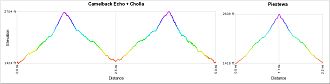
This is my favorite training hike and a staple during training season since it is local and can be accomplished before noon. It involves climbing both sides of Camelback Mountain (Echo first, then Cholla), and then driving over to Piestewa Peak and climbing that one too. Total accumulated elevation gain is about 3750'. "Trifecta" is a name I made up for this hike. No one else calls it by that name except me and my hiking buddy Doug Minderlen, who also has done this one. |
center>
Toms Thumb to Thompson Peak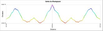
|
This is a hike that I put together after studying the map for the McDowell Sonoran Preserve. It begins at the Toms Thumb trailhead at the north end of the McDowell Mountains and follows trails southerly until intersecting Thompson Peak Road. Turn right and follow the road to the Thompson Peak summit. There are 3 significant climbs on the route: (1) Toms Thumb trailhead to the East End plateau, (2) Thompson Peak Road, and (3) the East End trail back up to the East End plateau on the return. I like this one because it offers a lot of elevation gain and more trail miles than some of the others. Thompson Peak road is STEEP, one of the steepest roads you will encounter, and a great leg workout. Accumulated elevation gain for the entire route is around 4200'. |
|
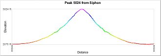
Known by most as "The Flat Iron", this hike begins at Lost Dutchman State Park and climbs Siphon Draw to the western Superstitions high point, Peak 5024. I typically skip going out onto the Flat Iron as I've been there many times before and that extra side trip doesn't add any significant elevation gain. This one is a real leg-buster and is sort of like doing two Camelback hikes back-to-back. Accumulated elevation gain to Peak 5024 is nearly 3000'. |
|
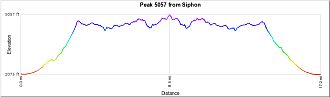
This hike is like the one above in that it begins at Lost Dutchman State Park and climbs Siphon Draw; however, instead of stopping at Peak 5024, continue on along the Superstition Ridgeline another 5 miles to its highpoint at Peak 5057. Retrace steps back to Lost Dutchman State Park. All in all, you are doing the western 2/3 of the Superstition Ridgeline in both directions, which is more difficult than doing the entire Ridgeline end-to-end. I've used this one as a R2R2R readiness hike, to gauge my fitness level before tackling the Canyon. Often, it leaves me depleted enough to doubt my fitness level. Accumulated elevation gain is around 5500'. |
|
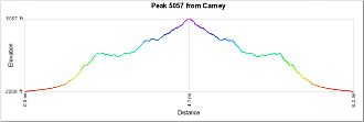
This one is similar to the one above in that the destination is highpoint Peak 5057 on the Superstition Ridgeline; however, it begins at the east end of the Ridgeline and traverses the eastern third and back. I don't use this one often because Siphon Draw to Peak 5024 gives almost as good of a workout with a shorter drive. This one is much better for solitude though. Accumulated elevation gain is around 3400'. |
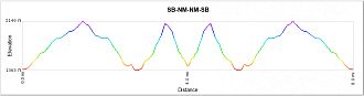 |
This was my original "long" training hike and one that I did regularly during the first 20 years. It is close to home and an easy one to knock off on the way home from work. Now that I am retired and have the time to go wherever I want, I rarely do this one since I have tired of it somewhat. The hike begins by going up the Shaw Butte road (start at the Central trailhead), down the backside of Shaw Butte, over to North Mountain and up its west side, and then down its SE side into North Mt. Park. Turn around and retrace steps back to the Central trailhead. When finished, you have climbed Shaw Butte twice and North Mountain twice for a total distance of about 10 miles an accumulated elevation gain of approx. 3000'. Not bad for a backdoor hike. I call it SBNM-NMSB. |
|
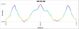
Related to the one above and using some of the same trails, this one begins at North Mt. Park, climbs North Mountain via its SE side, descends the west side, then over to and up the backside of Shaw Butte. Retrace steps back to North Mt. Park for 2 ascents of North Mountain and 1 of Shaw Butte. It is basically the same as above, except for a different starting point and that you don't go up an down the Shaw Butte road. This one is also close to home and a convenient one to do when I don't feel like driving very far or don't have a lot of time. Total accumulated elevation gain is around 2250'. I call this one NM-SB-NM. |
Lastly, of course anything to the river and back in the Grand Canyon is golden for training. |